
By Allan Cornford
Copyright © 2022 Allan Cornford. (Standard Copyright License.) All rights reserved. Independently Published through KDP. The images which are included for informative purposes only, are Screenshots, courtesy of Ewaranon’s YouTube documentary; ‘The Lost History of the Flat Earth’. All external links to images in the public domain, are courtesy from Wikimedia Commons and where possible, credits are given to each source. This I believe, comes under the term of Fair Use.
Probably set in the 1830s, Charles Dickens writes in the opening chapter of his 1852 novel ‘Bleak House’.
Miles William Mathis: Charles Dickens – Library of Rickandria
LONDON.
Michaelmas Term lately over, and the Lord Chancellor sitting in Lincoln’s Inn Hall.
Implacable November weather.
As much mud in the streets as if the waters had but newly retired from the face of the earth, and it would not be wonderful to meet a Megalosaurus, forty feet long or so, waddling like an elephantine lizard up Holborn Hill.
Dogs, undistinguishable in mire.
Horses, scarcely better; splashed to their very blinkers.
Foot passengers, jostling one another’s umbrellas in a general infection of ill-temper, and losing their foot-hold at street-corners, where tens of thousands of other foot passengers have been slipping and sliding since the day broke (if the day ever broke), adding new deposits to the crust upon crust of mud, sticking at those points tenaciously to the pavement, and accumulating at compound interest.
This is a fictitious story and doesn’t prove anything of course.
But it certainly suggests that excessive amounts of mud in the streets of London at the time, was not an unusual sight.
The UK is renowned for its thousands of sites where ancient Roman architecture has been discovered over the centuries
The latest being the partial remains of a 1,700 year old Roman villa, found buried beneath eight feet of soil on family-owned farmland in the summer of 2020, in Rutland County in the East Midlands of England.
When you start looking at some of the explanations for why all these architectural ruins are buried beneath several feet of dirt in a land not prone to volcanic eruption, earthquakes etc. it can get quite interesting.
Whilst severe flooding due to a nearby river bursting its banks would be quite plausible, one English history site tells us; When the Romans left Britain, it appears that some villas were covered with dirt to ‘trap’ into them the spirits of the Romans thus, they could not ‘escape’.
The truth is, old buildings, which in many cases are buried beneath up to 20 feet of soil, have been discovered on every continent on Earth.
Parts of Rome itself were buried in 20 to 40 feet of sediment which we’re told was due to the aqueduct system being in disrepair, hence the entire area got flooded.
As mentioned, some explanations (if given) are actually quite plausible, whereas others are based on guesswork.
But could there be a common factor for all of this?
Liquefaction
The phenomenon known as soil liquefaction commonly referred to as mud-flood, occurs when a cohesion-less, saturated or partially saturated soil, substantially loses strength and stiffness in response to an applied stress such as shaking during an earthquake or other sudden change in stress condition.
(Credit: Wikipedia)
Under these circumstances, material that is ordinarily a solid behaves like a liquid; much like an area of treacherous quicksand. =
Once the stress has subsided the soil begins to return to a solid state and in the aftermath, we see fully, or part buried structures, buildings tilted at an angle, and uneven, muddy streets where there was once tarmac or paving.
Mud can rise rapidly and dramatically with a destructive force which is unstoppable, causing massive landslides, affecting dams and bridges, and devastating entire areas of land, and in the worst-case scenario entire cities may be destroyed.
The New Madrid Earthquakes of 1811-1812, are often brushed over or barely gain a mention in textbooks.
After the February 7, 1812, earthquake,
”boatmen reported that the Mississippi actually ran backwards for several hours.”
(Credit: Wikipedia)
Although the 3 main earthquakes occurred in the central Mississippi Valley, they were felt as far away as:
- New York City
- Boston
- Montreal
and Washington D.C.
The thousands of aftershocks which followed, even caused soil liquefaction in parts of the Central United States.
(Credit: Wikipedia)
The June,16, 1964 Niigata earthquake in central Japan caused widespread liquefaction as too did the Alaska earthquake which occurred the same year.
Most of the city’s 5-story apartment blocks became quite steeply inclined and one of them was completely overturned.
Soil liquefaction was a major factor in the destruction of San Francisco’s Marina District during the 1989 Loma Prieta earthquake, and in the Japanese Port of Kobe during the 1995 Great Hanshin earthquake.
(Credit: Wikipedia.)
Liquefaction was largely responsible for the extensive damage to residential properties and the infrastructure of the eastern suburbs in the vicinity of Christchurch, New Zealand, during the 2010 Canterbury earthquake, and more extensively again following the earthquakes in early to mid-2011.
Some of the photographs show entire streets all partially buried in volumes of thick, gooey mud.
Most vehicles are completely submerged, whilst others have only a small portion of the roof showing.
The Great East Japan Earthquake of 2011 caused unprecedented damage.
Even areas 300 kilometers away from the epicenter suffered damages beyond what was predicted.
Soil liquefaction occurred over a large area.
Some 27,000 structures sank or tilted, causing massive damage.
On 28 September 2018, an earthquake of 7.5 magnitude hit the Central Sulawesi province of Indonesia.
Resulting soil liquefaction buried the suburb of Balaroa and Petobo village under almost 10 feet of mud.
The Indonesian Government is considering designating the two neighborhoods of Balaroa and Petobo, that have been totally buried under mud, as a mass grave site.
So yes, soil liquefaction, which can result in an unstoppable, fast flowing river of mud burying everything in its path is a well-documented phenomena.
A similar phenomenon known as Mud Boils, which are volcano-like cones of fine sand and silt that range from several inches to several feet high and from several inches to more than 30 feet in diameter.
Active mud boils are dynamic ebb-and-flow features that can erupt and form a large cone in several days, then cease flowing, or they may discharge continuously for several years.
They have been observed in the Tully Valley in Onondaga County, in central New York State, since the late 1890s.
(Credit: Wikipedia)
Mud or sand boils that emerge from asphalt roads, cause cars and buildings to start sinking, topple over or collapse.
Localized mud-floods are not that uncommon, but mud-floods occurring simultaneously in multiple nations within the same time period should be considered extremely rare.
Yet could it be possible that an earth-shaking event causing soil liquefaction which resulted in a devastating mud-flood occurred in the not too distant past?
One which drastically affected numerous locations across the earth simultaneously?
One positive aspect of soil liquefaction is the tendency for the effects of earthquake shaking to be significantly reduced; thus shockwaves are less likely to be transferred to buildings at the ground surface.
This could explain why the buildings in many towns and villages which appear to have been affected by mud flood in the past, were partially buried but not actually destroyed in the process.
Easter Island in the southeastern Pacific Ocean, is famed for the overly large stone heads, which stand like sentinels around its perimeter.
It wasn’t until 2012 when it was discovered that the 834 visible heads only made up for about three-eighths of the statues size.
With soil liquefaction as a possible cause, the 834 stone torsos and bodies which make up the bulk of the statues, were found buried upright beneath the ground.
There are at least thirteen leaning towers around the world, for which soil liquefaction is a possible cause.
The very fact the leaning tower of Pizza is still standing, albeit at an angle, after surviving soil liquefaction, is proof of how advanced the structural engineering and construction methods of the time were.
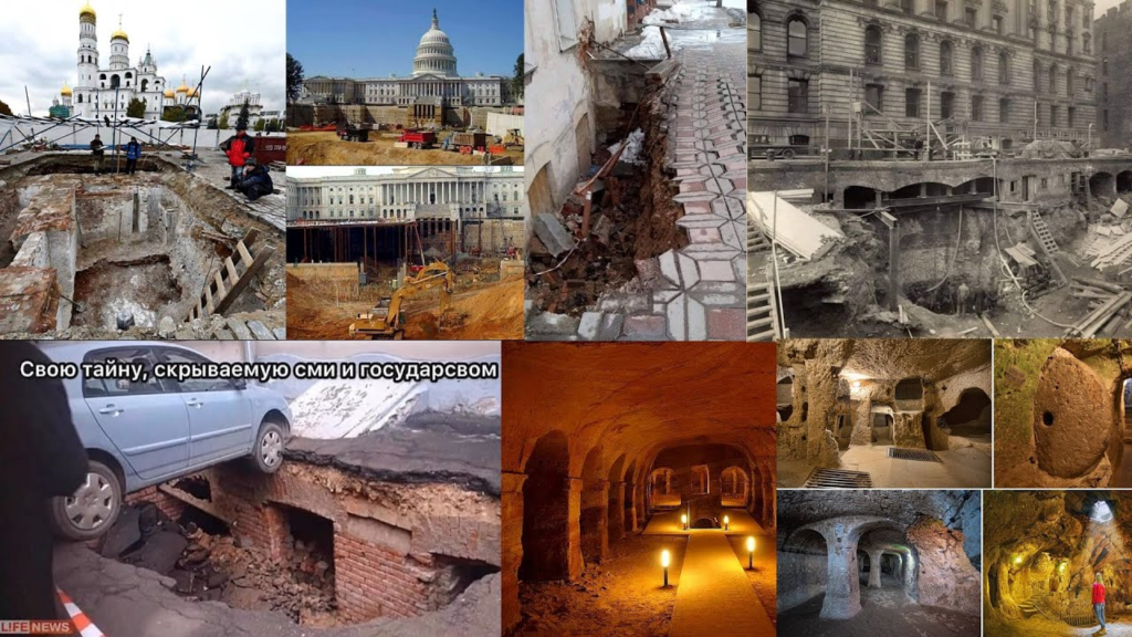
Why can so many old photographs from the late 19th century be found on the Internet of pretty much deserted towns and cities, with streets littered with debris, dirt and mud?
Some show huge mounds of soil and deep, gaping trenches being excavated in residential areas, which are maybe 75 or more yards in length, and 12-15 feet deep.
Many such images show teams of workmen clearing large mounds of soil, levelling the ground, and in some cases, seem to be excavating the lower two or three lower levels of existing structures.
The perspective some of these photos provide, clearly show the surrounding streets are at least 15-20 feet higher than they were originally.
Yet we are often given no official explanation to justify such excavations, nor the huge amounts of dirt and mud we see.
These photos also suggest that whatever the cause, something had happened in the fairly recent past.
The complete absence of a reasonable mainstream justification for the buried architecture and vast amounts of mud and dirt that we see, suggests that the controllers are deliberately trying to hide whatever happened in the past.
Photographs from Crimea around the end of the nineteenth century show streets buried by 9 to 12 feet of mud and clay, and the lower floors of buildings and pavements12 feet or more below ground level.
The image below is a screenshot from the documentary, ”Lost History of the Flat Earth.”

As can be seen by the mudline running along the entire length of the building, the surrounding streets were recently buried beneath 12 feet of mud.
Where did all this excess mud come from?
I recently viewed a similar photograph, taken in Russia I believe, of the front of a 2-story house, including the front door.
The street out front had been excavated to reveal the previously buried front door and a couple of windows of the original ground floor level.
It is evident from the photograph, that rather than clear all the excess mud, an extra 2 storys were added to the original ground floor.
In fact, there are numerous examples of old buildings that have been excavated showing previously hidden lower levels.
Where did all this extra mud/dirt come from?
Many late 19th century images can be found of cities in eastern Europe and Russia, which show deserted streets that appear to have been levelled and with much of the mud removed.
It is estimated that in many cases, prior to removal the layer of excess mud in the streets was on average around 3 feet deep.
Often these photographs of unrefined and muddy streets are set against a backdrop of refined, sophisticated and magnificent architecture.
Could these cities have suffered a similar fate of soil liquefaction that we have seen in more recent times? Perhaps, but realistically, muddy roads is not enough to base any conclusions on.
It could also be argued of course, that seemingly deserted towns and cities, was likely the result of the long-delayed exposure time of the earliest cameras.
For unless people remained stationary for the duration of the exposure, they probably wouldn’t appear in the photo.
At the same time however, there is also a noticeable absence of handcarts and wagons parked up, of the type used by street vendors and delivery men etc. that one might expect to see in the cities.
And it wouldn’t explain why many of the streets look filthy and littered with debris, almost as though they had recently been awash with mud.
Some claim such photos of empty cities, were taken in the early morning hours, before local residents were up and about.
The problem here is, the angle and length of the shadows in some of the images, which indicate the photos were taken closer to, or around midday.
One thing is certain, whoever took these photographs of deserted cities, especially those which show a panoramic view of the entire area, done so with intent.
The viewer is meant to see it.
Whatever the case, to see images of these empty towns, is actually quite disturbing.
In some ways they remind me of my hometown during the first Lockdown, only far worse.
At least I saw a handful of people in the streets, albeit most looking rather bewildered as they peered at me from over the top of their mask.
And why are there so many old residential buildings that have lower floor windows situated below, or mostly below ground level with only the top section of glass visible from outside?
I’m sure we’ve all seen them at some point in our lives.
There are even a number of old churches and other buildings, with the sunken windows, and in some cases doorways, entirely below ground level.
Were they built with an entrance or window partially, or even below ground?
Or were they originally constructed prior to a localized mud flood, the aftermath of which, raised the ground level of the area surrounding them?
Making the original ground floor now appear to be the basement?
One is hard pushed to find any photos which show the construction of these possible mud flood buildings.
I’ve been told by a Ukrainian, now living in England, that many of the buildings in his former hometown, have the first floor underground.
At first glance, he says, it’s not always easy to tell, because they have been remodeled.
But if you look at some of the old, abandoned buildings, you can clearly see the doors and windows of the first floor are beneath the level of the roads.
Evidently, much of Russia is the same.
Investigative researchers have even discovered many old buildings in American cities with 2 or more floors below street level.
One researcher describes them as being:
“quite elaborate, with decorative brick arches in what are supposed to be sewers and cellars—and seemingly intentionally ruined.”
More often than not, the buried masonry etc. is consistent with the architecture seen in the buildings above ground.
Some photos show Russia’s Winter Palace

The Winter Palace is a palace in Saint Petersburg that served as the official residence of the House of Romanov, previous emperors, from 1732 to 1917. The palace and its precincts now house the Hermitage Museum.
the US Capitol Building

The United States Capitol, often called the Capitol or the Capitol Building, is the seat of the United States Congress, the legislative branch of the federal government. It is located on Capitol Hill at the eastern end of the National Mall in Washington, D.C. Although no longer at the geographic center of the national capital, the U.S. Capitol forms the origin point for the street-numbering system of the district as well as its four quadrants. Like the principal buildings of the executive and judicial branches, the Capitol is built in a neoclassical style and has a white exterior.
and New York’s St. Mary Magdalene church

The Church of St. Mary Magdalen is a former Roman Catholic parish church under the authority of the Roman Catholic Archdiocese of New York, in Manhattan, New York City.
having been completely dug out around the base, to reveal lower levels than were previously known about.
A simple Google search will let you see at least a dozen of these buildings.
NWO: MEDIA: TECH: Google’s True Origin Closely Tied to the CIA – Library of Rickandria
But once you see this sunken infrastructure which is so prevalent across the earth, you can never un-see it. =
One has to question why there are so many photographs of entire lower levels of buildings being dug out, with no explanation as why they were submerged in the earth in the first place?
To help put things into perspective, numerous black and white photographs from the nineteenth century can be found of various cities across the world, with primitive dirt streets, and pedestrians, or workmen standing alongside horse and carts, with impossible buildings towering in the background.
Why spend what must have amounted to a small fortune, to erect such elaborate and costly structures, when the roads surrounding them are so basic by comparison, and the local residents appear to be so relatively poor?
Time and again we see old photographs of unrefined and dirty streets, simple, terraced dwellings and poverty, with magnificent regal buildings standing in the background.
In fact, complete with Gothic spires, and huge columns adorning their marble-stepped entrances, they tend to stick out like a sore thumb, compared with the majority of buildings around them.
Once again, there appears to be two conflicting stories in the same narrative.
Rarely, if ever, can photographs be found, of these buildings under construction.
To be fair, the occasional old photograph of workmen wielding a shovel, or accompanied by a horse and cart, are not evidence of anything.
Could these elaborate grand structures, which seem so out of place in their local surroundings, have been erected prior to a massive mud flood, and have since been reclaimed and renovated?
I don’t know the answer either but have my suspicions and feel it’s worth thinking about.
There’s an official explanation for nearly everything of course, but time and again, anomalies can be seen in many old photographs that seem bizarrely out of character, especially for the time period they were supposedly built in.
In the main, an official explanation is merely a cover story.
A cover story being a story that conceals some other atrocity or catastrophe by hiding the real cause of the atrocity.
As it stands, the argument for a worldwide Mud Flood is relatively weak, yet it is probably unwise to dismiss the possibility of soil liquefaction occurring at multiple locations across the realm simultaneously.
For although the Scriptures doesn’t actually mention a mud flood, they describe earth-shaking events, which we are told are the main contributing factor for Soil Liquefaction.
On three occasions the Bible records how, God will shake the heavens and earth, and a time is foretold when the foundations of the earth will shake, be moved exceedingly, and reel to and fro like a drunkard.
And it shall come to pass, that he who fleeth from the noise of the fear shall fall into the pit; and he that cometh up out of the midst of the pit shall be taken in the snare:
for the windows from on high are open, and the foundations of the earth do shake.
The earth is utterly broken down, the earth is clean dissolved, the earth is moved exceedingly.
The earth shall reel to and fro like a drunkard, and shall be removed like a cottage; and the transgression thereof shall be heavy upon it; and it shall fall, and not rise again. Isaiah 24:18-20
For thus saith the LORD of hosts; Yet once, it is a little while, and I will shake the heavens, and the earth, and the sea, and the dry land; So yes, in light of Bible prophecy, catastrophic mud-floods affecting multiple nations simultaneously, certainly cannot be ruled out. Haggai 2:6
Loess Wikipedia describe the natural phenomena known as loess, as being a wind-borne sediment consisting of grain-sized particles of rock, clay, sand and silt that covers around ten percent of Earth’s entire land surface area.
Loess deposits, which can range in depth or thickness, from a single decimeter to several tens of meters, are widely distributed across many provinces in China, and are found across the entire European continent.
Evidently loess can easily be removed with a shovel, yet at the same time is firm enough to be carved out to form a simple cave dwelling, known in China as a yaodong or ”house cave”.
In 2006, an estimated 40 million people in northern China lived in yaodongs.
Beneath the old German town of Oppenheim, famous for its wine production, there exists approximately two hundred kilometers of connected tunnels and wine cellars, dug laterally through the thick bed of loess.
In North America loess covers the plains of the Platte:
- Missouri
- Mississippi
- Ohio
rivers and the Columbia Plateau.
In fact, loess deposits of varying thickness can be found in most all nations on Earth.
We are told that dependent upon the force of wind energy, these deeper or thicker layers of loess, have gradually accumulated
”over a sufficient amount of time,”
although according to Wikipedia, it’s reckoned the loess deposits in North America, are less than 30,000 years old.
I’m not a geologist, but is it possible that in some areas of the U.S. much of the loess has been deposited very rapidly in far more recent times?
For why are there photos of a number of buildings constructed 150 or so years ago in Kansas, that are surrounded by huge mounds of loess deposits known as bluffs, which stand up to 50 feet tall or more?
The obvious answer would be that the buildings were erected in the vicinity of these vertical mounds of soil.
Yet whilst numerous old photographs from the 1860’s can be found of roads being dug out and levelled in the proximity of buildings, to find a photograph of an actual building under construction is extremely rare.
Thus far in fact, I’ve not been able to find a single one.
CONTINUE
BOOK: EXCERPT: Tartarian Rule? Or Millennial Kingdom? – Birth of a City – Library of Rickandria
BOOK: Tartarian Rule? Or Millennial Kingdom? – Library of Rickandria
BOOK: EXCERPT: Tartarian Rule? Or Millennial Kingdom? – Mud flood