
The Location of Paradise (Genesis 2:10-2:14)

by Damien F. Mackey
Introduction
In 1999 there appeared in the colour supplement to The Weekend Australian newspaper an article by David Roth [*] “In Search of Eden”, which was a serious attempt by Roth to locate the original Eden.
The article was prefaced by:
Did Eve tempt Adam with the apple?
Did God banish them from Paradise?
Regardless of your religious beliefs, evidence suggests the Garden of Eden was based on a real place.
Archeologist and author DAVID ROTH followed a trail of clues to western Iran to see if God was still receiving visitors.
* Strangely, whilst there is actually a David Roth who is involved with the UK historical revisionist group Society for Interdisciplinary Studies, this particular newspaper article on Paradise is virtually identical to that presented by another UK revisionist, David Rohl, in his The Lost Testament (Century, 2002), Chapter One.
Roth next wrote:
Since the time of the Jewish historian Josephus, a near contemporary of Christ, scholars have tried to use Genesis II to locate Eden, but the problem has always been the identification of the rivers.
The Bible calls them Perath, Hiddekel, Gihon and Pishon.
The first two are easy to decipher:
the Perath is simply the Hebrew version of Arabic Firat and Greek Euphrates:
similarly, the Hiddekel is Hebrew for Sumerian Idiglat from which the Greek Tigris derives.
The remaining two rivers, however, have always been a mystery.
In order to locate Eden precisely, I needed to find the sources of all four.
As will become apparent soon from a consideration of Professor A. Yahuda’s discussion of these same primæval rivers (in The Language of the Pentateuch in its Relation to Egyptian, p. 3. “The Location of Paradise” and p. 4.‘The River of Paradise and the Four Rivers”), Roth is immediately out of step with Genesis 2 in his trying to locate the four rivers actually in Eden (Paradise).
Roth, following one whom he calls the “amateur historian Reginald Walker”, proceeds to identify the biblical Gihon with
“… the river Aras, flowing into the Caspian Sea from the mountains north of Lake Urmia [which river] was once called Gaihun.”
The Pishon, he identifies with
“… the river Uizhun (the modern Kezel Uzun) … [which] flows from the mountains of Kurdistan and empties into the southern basin of the Caspian Sea.”
Thus, he locates the ancient Eden in eastern Turkey/western Iran, specifically the regional capital of Tabriz.
From this base, Roth believes himself even able to propose a location for:
the biblical “land of Nod” which became Cain’s home.
Cain and Osiris – Library of Rickandria
Thus:
Even further to the east of Tabriz and the Adji Chay valley in which it is located … is the land of Nod into which Cain was exiled after he had murdered his brother Abel.
The area today is still called Upper and Lower Noqdi … (“Belonging to Nod”).
and to ‘explain’ the Cherubim of Genesis 2:
In the same region we find the town of Kheruabad.
The name means “settlement of the Kheru people”:
and the Kheru were the Kerubim (Cherubs) of Genesis who protected the eastern entrance into Eden.
The volcanic peak which guards the eastern gateway back into the Garden of Eden is a good candidate for the “Fiery Flashing Sword” associated with the Kerubim.
Lucifer’s Flood & the Little Season – Two Gardens – Library of Rickandria
I: The Four Rivers According to Professor A. Yahuda
Professor Yahuda, too, had taken seriously the notion of a real Eden and had also accepted as a common denominator that the Tigris and Euphrates of Genesis 2 referred to the two great Mesopotamian rivers.
He though, whilst following the same biblical ‘road map’ as Roth, had not untypically located the famous Garden closer to Egypt (though definitely not in Egypt).
He did not miss the fact that in Genesis 13:10 the Garden of God is likened to Egypt.
And Lot lifted up his eyes, and beheld all the plain of Jordan, that it was well watered every where, before the LORD destroyed Sodom and Gomorrah, even as the garden of the LORD, like the land of Egypt, as thou comest unto Zoar.
Yahuda’s line of reasoning led him to look for the Pishon and Gihon to the west of the two great Mesopotamian rivers, rather than – as in Roth’s case – to the east.
His consistent advice to any would-be locaters of Paradise – advice that is certainly pertinent to Roth – was (pp.162-3):
In all attempts to find a solution to the question:
‘Where lay Paradise?’, the greatest difficulty has always been the assumption that the rivers Pîšôn of Hawîlâ and Gîhôn of Kûš, as well as the Mesopotamian rivers Tigris and Euphrates, flowed through Paradise itself, and in any case belonged to Paradise.
This made it impossible to obtain a clear idea of the geographical situation of Paradise, whatever view was taken of the names of the first two rivers and wherever they were localized, because in no case could the confluence of all these four streams in one place be explained.
At the outset, it must be pointed out that in Gen. 2:10ff. there is not the slightest support for the assumption that the four rivers flowed through Paradise; nay, it is expressly stated that ‘one river went out from Eden to water the garden’.
It was therefore exclusively this one river, having its source in Eden, i.e. in the oasis, that flowed through Paradise, and the four rivers mentioned immediately afterwards have actually nothing to do with Paradise itself.
Thus, Roth’s contention that:
“… the problem [of locating Eden] has always been the identification of the rivers …”
turns out to be not really the crucial factor.
The chief “problem” is actually to identify the
“… one river that went out from Eden to water the Garden.”
Roth, in trying to locate all four rivers in Paradise – and, consequently, his being forced to locate the Pishon and Gihon in the region of Armenia, suitably close to the Tigris and Euphrates in Mesopotamia – is in actual fact returning to the viewpoint advanced at the beginning of the C18th by Reland.
I take up Yahuda again on this subject (p. 171):
Even the ancients were governed by the idea that the four rivers were world streams, and sought to identify them with the rivers known in their day as the most important.
Thus e.g. in Josephus’s time (Antiquities, I, § 38 f.) the Pîšôn was identified with the Ganges or Indus, and the Gîhôn with the Nile.
In later times this idea that the Paradise rivers were world-streams, though in itself correct, was rejected because in the absence of a right understanding of Gen. 2:10 it only made the Paradise problem more complicated.
To evade this difficulty the Pîšôn and Gîhôn were sought in Mesopotamian rivers, and so long ago as 1706 Reland, De Situ Paradisi, identified the Pîšôn with the Phasis and the Gîhôn with the Araxes in Armenia ….
Although Reland, and after him Delitzsch and others, contrived on purely phonetic grounds to interpret Kûš as the land of the Kossaeans, all attempts failed to identify Hawilâ as a Mesopotamian land.
Genesis 2 Edited
Interestingly, in light of P. J. Wiseman’s thesis (Ancient Records and the Structure of Genesis,Thos. Nelson, 1985) that Moses had, for the sake of his contemporaries, added geographical indicators to the family histories of his forefathers, Yahuda was convinced – as are others – that the description of the four rivers is an editorial gloss to an original document.
Now that original document would be, according to Wiseman, Adam’s toledôt or “family history”.
Verses 8-10 of this particular history describe in most uncomplicated terms God’s planting of a Garden in Eden, and its flora and hydrography, to which Moses would have added the geographical indicators (Verses 11-14).
We can set out this literary development as follows:
ADAM’S ORIGINAL ACCOUNT
And the Lord God had planted a paradise of pleasure from the beginning; wherein He placed man whom He had formed.
And the Lord God brought forth of the ground all manner of trees, fair to behold, and pleasant to eat of:
the tree of life also in the midst of paradise: and the tree of knowledge of good and evil.
And a river went out of the place of pleasure [i.e. Eden] to water paradise [i.e. the Garden], which [river] from thence is divided into four heads.
TO WHICH MOSES ADDED
The name of the one is Phison [Pishon]:
that is it which compasseth all the land of Hevilath [Hawila], where gold groweth.
And the gold of that land is very good:
there is found bdellium, and the onyx stone.
And the name of the second river is Gehon [Gihon]:
the same is it that compasseth all the land of Ethiopia.
And the name of the third river is Tigris:
the same passeth along by the Assyrians.
And the fourth river is Euphrates.
The Sumerian Swindle – How the Jews Betrayed Mankind – (5000 BC to 1500 BC) – Vol. I – Library of Rickandria
Similarly, Moses had added parenthetically to Genesis 14 the new names of five places recorded in that ancient history; most notably “Vale of Siddim” to which he appended:
“(which is the Salt Sea)” (v. 3).
This very Jordan valley is indeed likened – before catastrophe had engulfed the region – to the Garden of Eden:
“Looking around, Lot saw all the Jordan plain, irrigated everywhere, like the Garden of God …”.
This makes it perfectly clear that the recorder of Abra[ha]m’s history had knowledge of what Eden had actually been like, and that this blissful place had not been some fanciful, imaginary land totally unlike anything that Abra[ha]m knew.
But, like Paradise, the Jordan plain, would become devastated.
For editor Moses goes on to add, as he was wont to do, his explanatory note (here in regard to the fact that the land had previously been well-watered):
“…this was before Yahweh had destroyed Sodom and Gomorrah as far as Zoar” (Genesis 13:10).
Similarly, again, in the case of Adam’s tôledôt, Moses added the above-mentioned geographical indicators in order that his contemporaries would be able to identify the four world rivers about which the original writer gave hardly any detail.
I previously quoted Yahuda’s evidence (op. cit., pp. 163-4) that editing had occurred right here.
Yahuda proceeded from this to suggest why he thought it was necessary to locate Eden and its Garden to the west, rather than to the east, of Mesopotamia:
… assent could not be given to Mesopotamia being the home of Paradise as the other two rivers flow through lands which are far removed from Mesopotamia, namely Kûš, which in the Bible means exclusively Nubia or Ethiopia, and Hawîlâ, which according to Genesis 10:6,7 lay near Kûš, but according to 10:29 somewhere in Arabia; nor, on the other hand, is it possible to take Egypt, Ethiopia or Arabia as the home of Paradise, because then the two streams of Mesopotamia would not fit in.
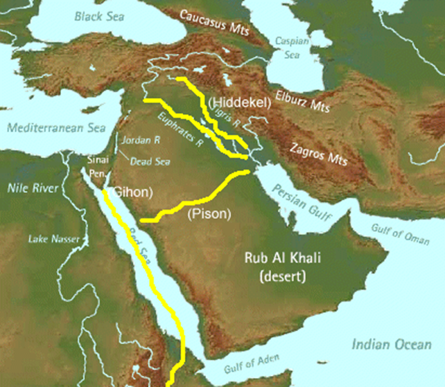
Roth had for his part, appropriately to his own geographical reconstruction – but contrary to the more traditional view that the land of Kûš, watered by the river Gihon, pertained to Ethiopia/Cush – identified Kûš with the region of mount Kusheh Dagh in Armenia:
The Ahara Chay is a major tributary of the Gaihun-Aras/Gihon which, according to Genesis II, “winds all through the land of Cush”.
My map confirmed once more that we really were in the primordial landscape of Adam and Eve.
Separating the Ahar and Adji valleys, and acting as the northern wall of the Garden of Eden, stretched a high snowcapped ridge named Kusheh Dagh, the Mountain of Cush.
Ingenious though this all is, I think that Yahuda’s account of Kûš (Cush) is by far the better one – and I shall soon explain why.
Thus, despite the footnote in The Jerusalem Bible (7, n. 2a, emphasis added) that
“… the rivers Pishon and Gihon are unknown, and the two ‘lands’ named are probably not the regions designated elsewhere by the same names”,
I fully embrace Yahuda’s view that Cush should retain its traditional meaning of Ethiopia.
In Genesis 10:7 and 8, Kûš (Cush) is Ham’s son.
Indeed, if it is correct to regard Genesis 2:11-14 as an explanatory gloss added by Moses, as I do, then Kûš could only refer to Ethiopia.
As I have shown in a series of articles for The Glozel Newsletter [Waikato, N.Z.], pharaonic Egypt of Prince Moses’s Day was busy extending its southern border into Ethiopia, or Cush.
Moreover, Jewish tradition has it that Moses led successful military expeditions for Pharaoh against Ethiopia, and that he even married an Ethiopian princess (though the last is perhaps a confusion with Moses’s marrying Zipporah, the daughter of a Midianite chieftain).
(i) The Tigris and Euphrates
Though referred to in the Genesis account after the Pishon and the Gihon, I shall deal with the Tigris and Euphrates first because both Roth and Yahuda are in agreement as to their identification.
The great Mesopotamian [Iraq] rivers Tigris and Euphrates are well-known even today, and Roth and Yahuda unhesitatingly identify these with the rivers of the same name in Genesis 2.
Now, any doubt I think that the antediluvian rivers known to Adam (whose later names Moses added) may be different from the present day rivers is removed by editor Moses’s telling us specifically:
“And the name of the third river is Tigris:
the same passeth along by the Assyrians”
(var. “to the east of Ashur”) (v.14), which is perfectly accurate since the city of Ashur, the religious capital of Assyria, was situated on the west bank of the Tigris (unlike Nineveh, the political capital, on its east bank).
The C2nd BC Book of Sirach (or Ecclesiasticus) provides us with a further ancient testimony of these four rivers of Genesis 2, even apparently as then currently active; but now with the inclusion of two new names, the Jordan and the Nile, that may well provide us with a clue to the all-important, but un-named river of Paradise itself (Sirach 24:25-27):
This is what makes wisdom brim like the Pishon,
like the Tigris in the season of fruit,
what makes understanding brim over like the Euphrates,
like the Jordan at harvest time;
and makes discipline flow like the Nile,
like the Gihon at the time of vintage.
Some argue that the “Gihon” here is being identified with the Nile; whilst others prefer, from their interpretation of the parallelism used here, that Sirach had six rivers in mind.
Yahuda, as we shall now find, will conclude quite independently from this that there is a connection between Gihon and the Nile, that the Gihon is in fact the Nubian Nile.
(ii) The Pishon and Gihon
Yahuda now turns to the other two rivers (pp. 171-2):
Now what rivers were meant by Pîšôn and Gîhôn? Starting from the foregoing standpoint and considering that the Euphrates and Tigris lay in the extreme east of the then known world, one cannot go far wrong in assuming that it was the author’s [sic] aim to set against the Mesopotamian pair of rivers another pair at the opposite end of the world, viz. in the extreme west.
This assumption is confirmed first of all by the statement that the Gîhôn flowed through Kûš, which in the Bible invariably denoted Nubia or Ethiopia, and which, according to the geographical conception of those days, actually lay at the extreme western end of the world.
If one further considers that the two Mesopotamian rivers flow near to one another, framing, so to speak, the eastern part of the world, one may assume that similarly in the choice of the opposite pair of rivers, Pîšôn and Gîhôn, the idea was dominant that they, too, flowed near to one another and delimited the extreme western part of the world.
Yahuda found the task of identifying the Gihon:
“… greatly simplified by the mention of Kûš, 2:13, whereby we are left in no doubt as to its course.”
There is little disagreement, he said,
“that when, in Egypt … reference was made to Kûš in a general way, the Nile region between the first and the fourth cataract alone was meant.”
And:
It follows that the Gîhôn, described in Genesis 2:13 as ‘going round the whole land of Kûš’, can be no other than the Nubian Nile, i.e. that portion of the Nile which compasses the region that, as we have shown, is identical with Kûš proper.
The emphasis on the ‘whole land of Kûš’ indicates the author’s [sic] desire to determine exactly the length of the river covering the entire extent of the Kûš of his time, namely southern and northern Nubia, beginning at the first cataract.
Those interested can read for themselves Yahuda’s explanation as to why he thought Gihon was an appropriate name for the Nubian Nile (pp. 184ff).
Now to the Pishon:
Now that the Gîhôn question can be considered as solved, let us turn to the Pîšôn, and on the strength of the description of the region watered by it as a land of gold, bdellium, and šôham (malachite or emerald), attempt to identify the land of Hawîlâ.
Of great importance for our investigation is the description of the gold, Gen 2:12 as [zahav tov] ‘good gold’.
This is not to be taken as a general characterization of the quality of the gold, but as a literal reproduction of the technical expression in Egyptian, nb nfr ‘good gold’ for ‘fine’ gold as distinct from all other kinds of gold. ….
Such precision in the qualification of the gold can only be explained by the author’s [sic] familiarity with the products of the land of Hawîlâ and his knowledge of its river.
After a detailed examination of all relevant gold-yielding places Yahuda, for the Pishon region, opted for:
…. The gold mines of the so-called ‘Arabian desert’ on the Egyptian side, south-east of upper Egypt, between Assuan, Koptos (the present Kuft), and the Red Sea.
According to Egyptian monuments this district was one of the richest sources of gold; and from the Redesiyye inscription of Seti I … we learn that these gold mines were extraordinarily productive.
This district was moreover very famous on account of the Wâdî Hamamât quarries….The boundaries of these mines can be exactly determined:
in the north is the ancient caravan route of Kene on the Nile to Qosêr on the Red Sea, and in the south is the line that runs in a south-easterly direction from the district of Gebel el-’Allâqi down to the Red Sea.
… It was in this district that the Egyptians … had the most important gold mines after Nubia.
Of particular significance is the fact that of the principal Egyptian gold fields no less than three, namely Koptos, Edfu, and Ombos, are to be found in this district, and that their names appear as descriptive import-marks for gold, viz.
- ‘Gold of Koptos’ (nb n gb.tyw),
- ‘Gold of Edfu’ (nb n db3), and
- ‘Gold of Ombos’ (nb n nbt).
Moreover, this same region yielded the exact precious stones that the editor had ascribed to the environs of the Pishon:
… this gold land is of still deeper interest as it was very rich both in malachite and in emeralds; so much so that apart from the Sinai Peninsula, which for many centuries supplied Egypt with large quantities of malachite, it was the most productive source of this semi-precious stone.
We have thus established the fact that of the three products which in Gen. 2:11 f. are described as proper to Hawîlâ, the most valuable, gold and malachite (or emerald), certainly came from the district of the Arabian desert.
Yahuda therefore concluded re the course of the Pishon:
… it logically follows that Pîšôn can only mean that portion of the Nile which circumscribes the gold-land of upper Egypt, and which, in contradistinction to the Nubian Nile, we would call the Egyptian Nile ….
In the Pîšôn and the Gîhôn we have thus the two portions of the Nile which in those days were regarded as two separate rivers; they were then the most important and best known in the western part of the world, just as the two other world rivers, the Tigris and the Euphrates, were in the east.
Again those interested may read through Yahuda as to why he thought the name Pishon was appropriate to this part of the Nile.
Yahuda’s conclusion that the Pishon
“… can only mean the portion of the Nile which circumscribes the gold-land of Upper Egypt”,
would perhaps account for why Sirach named Pishon distinctly from the Nile (which latter flows northwards right down to the Delta of Lower Egypt).
Moses, as we saw, had added to the statement in Isaac’s tôledôt document that the Ishmaelites had
“settled from Havilah to Shur” (25:18),
that this was:
“opposite Egypt in the direction of Assyria.”
The New English Bible translates it as:
“east of Egypt on the way to Assyria.”
This would seemingly fit in with Yahuda’s explanation that “Hawîlâ” was in the Arabian desert next to (but east of) Egypt.
This basic matrix for the four rivers, though, has since been modified, and, I believe, greatly improved upon, in an article, “The Lost Rivers of the Garden of Eden”, that can be read at:
The Rivers of the Garden of Eden
The author here skillfully aligns the four rivers with the Great Rift geological system:
….
If we have correctly identified all four rivers, we now have 2 rivers (Euphrates and Tigris) originating today out of Turkey and another running down what was is now the Red Sea south of Israel and deep into Africa, following the path of the present-day Great Rift system.
For the moment, we will also include the previously discussed “fossil river” running through Saudi Arabia.
Look at the same map again:

The yellow lines show the paths of the four rivers as proposed from what we have discussed so far.
You should note that we did not trace over the Euphrates and Tigris rivers to their present-day sources but terminated them close to the Great Rift fault zone line.
You will also note that we have not continued the proposed path of the “Gihon” beyond the top of the Red Sea and have terminated the proposed “Pison” at the Great Rift fault zone line.
And here follows the key issue:
All 4 of these rivers have one thing in common:
All are connected to the Great Rift system.
And that is the key to the mystery.
Two rivers presently originate out of Turkey to the north and two other fossil rivers flowed south of Israel.
The geographical “center” of these four points of flow is neither Turkey nor Kuwait; the center is somewhere near the general region of present-day Israel and Jordan.
The Bible itself lends further credence to Israel (or someplace nearby) as the location of the Garden of Eden.
If you run the name “Eden” through a search of the Bible, among several references the following ones provide some insightful clues:
“Behold, the Assyrian was a cedar in Lebanon with fair branches, and with a shadowing shroud, and of an high stature; and his top was among the thick boughs.
The waters made him great, the deep set him up on high with her rivers running round about his plants and sent out her little rivers unto all the trees of the field.
Therefore, his height was exalted above all the trees of the field, and his boughs were multiplied, and his branches became long because of the multitude of waters, when he shot forth.
All the fowls of heaven made their nests in his boughs, and under his branches did all the beasts of the field bring forth their young, and under his shadow dwelt all great nations.
Thus, was he fair in his greatness, in the length of his branches:
for his root was by great waters.
The cedars in the garden of God could not hide him:
the fir trees were not like his boughs, and the chesnut trees were not like his branches; nor any tree in the garden of God was like unto him in his beauty.
I have made him fair by the multitude of his branches:
so that all the trees of Eden, that were in the garden of God, envied him.”
(Ezekiel 31:3-9 KJV)
In this passage the Bible says that the Assyrian was in Lebanon.
Spiritually speaking, the “trees” in this passage refer to men and leaders.
Cedar trees are mentioned elsewhere in the Bible as references to Lebanon –
- Judges 9:15
- Psalms 29:5 & 104:16
- Song of Solomon 5:15
- Isaiah 2:13
- Jeremiah 22:23
and more.
Notice also in the last of the passage that the Spirit associates the trees with “Eden” that
“were in the Garden of God.”
Lebanon, although not a part of modern political Israel, was a part of the Biblical lands ruled by the Kings of Israel in times past.
From this we can infer that the Garden and the source of the rivers of the Garden was somewhere close to the land of Lebanon.
Assuming this postulation is correct, that the source of the four rivers was somewhere near Lebanon, the interconnection of the river systems would need to be somewhat like the map below:

What roughly emerges, when all four rivers are connected to trace of the Great Rift fault system, is a complex river network emerging from a common point of origin that flows both north and south, with each north and south extension splitting into two separate streams, for a total of four rivers.
That adds up to four separate heads.
The author of this excellent article has rightly concluded that the ancient rivers had arisen from a source different from that of today, and that their courses then, too, were different:
Of course, to propose such a reconstruction one would have to assume that the present-day headwaters of the Tigris and Euphrates were not the main source headwaters in ancient times.
It is possible that there could have been older main tributaries previously flowing from Lebanon which were, at that time, the main headwaters of those two rivers.
But the so-called Kuwait River, which has been proposed as the lost river Pison, does not seem to match with the common denominator of the others, that is the Great Rift and branching fault systems.
Based on the description of its path in the Bible which says,
“compasseth the whole land of Havilah”
and knowing from the geology of present day Yemen that onyx can be found there, then this part of the verse,
“where there is gold; And the gold of that land is good: there is bdellium and the onyx stone”
suggests an alternate path for the River Pison, to the south of Yemen, and that would give us the path indicated by the blue and yellow markings on the next graphic.
When all factors are considered (Bible text and geology) … the paths indicated by the dotted lines on the large map below [see original article] are probably where those rivers flowed.
And a southern path around Yemen puts the fourth river squarely into the basin of the Great Rift system, flowing east from the upwelling Afar Triangle.
….
These paths meet the requirement of the Biblical text because the single river water source, originating from high ground somewhere in or near present day Israel, hits the Rift Valley, then would have flowed both north and south along the path of the Rift zone, with both the north and south forks each splitting a second time when intercepting other fault zones.
….
Keep in mind that the course of rivers around and through the vicinity of the Great Rift fault system may have changed or dried up because of block faulting all along the Rift zone.
….
The author has concluded, as have I, that the Garden of Eden must have been situated in the land of Palestine (I would say more specifically at the site of Jerusalem):
JERUSALEM – Library of Rickandria
Now, returning to the general area of Lebanon as the Biblical location of the Garden of Eden and the water source for the four rivers, let us take a look at the present-day geology and topography of that area.
This map shows a great deal of block faulting in the area of Lebanon just north of modern-day Israel.
….
Below is a satellite image of the entire area [see original article].
You will note from the topographical relief that, had waters once flowed out of this area, they would naturally flow northward into the Euphrates Fault system river basin.
At the time of the Garden of Eden the main headwaters of the Euphrates could have come from that direction.
If the water flow at that time continued northward along the path of the Great Rift, it would also intersect the present-day Tigris River basin.
The prominent bodies of water along the Rift zone in this photo are the Dead Sea (bottom) and Sea of Galilee (top).
They are connected by the Jordan River which flows south.
Before the Earth was divided by the Rift, the mountainous land on both the Israeli and Jordanian sides were joined.
You are looking at “ground zero” of what was once the Garden of Eden. ….
The Ancient River System
The antediluvian system of irrigation described in Genesis 2:5, whereby Eden was watered, not by rain but by a river – by one river – has continued to prevail in Egypt as Yahuda explained:
And every plant of the field before it was in the earth, and every herb of the field before it grew: for the LORD God had not caused it to rain upon the earth, and there was not a man to till the ground.
These are conditions which apply in much greater measure to Egypt than to Mesopotamia, where the origin of the Paradise story is sought, especially as Mesopotamia has a quite abundant rainfall so that its irrigation is not exclusively dependent upon its rivers.
… This contrast between Egypt and other lands dependent on rain for their fertilization, was in the mind [sic] of our author in contrasting Eden, exuberantly fertilized by river-water, and the dry and barren ‘red earth’ longing for rain.
(Cf. Job 36:27; Sirach 24:3).
Little wonder, then, that the Garden of Eden is likened in Hebrew literature to Egypt!
Yahuda, after he had given meanings, or related meanings, for the Hebrew word Eden, such as
‘bodily vigour’
‘youthfulness’
‘blooming, exuberant woman’
‘exquisite delicacies’
‘to be fat and luxurious’
concluded that Eden was a most luxuriant oasis:
All this leads us to discern in [Eden] the word for oasis in contrast to [adamah] (p. 139).
As a matter of fact the expression ‘and God planted a garden in Eden’ (Gen. 2:8) clearly premises that ‘Eden’ designates a particular kind of spot with special characteristics in which the garden was planted.
Accordingly, [gan beayden] means merely that the garden was planted in an oasis, an ideal spot for a flourishing garden of unusual luxuriance….
From there Yahuda went on to discuss the origin of the four rivers:
As far as [roshim] ‘heads’ is concerned, it has been frequently pointed out that it can hardly denote ‘head streams’ because, on the assumption that they went forth from one river, they ought to be described rather as subsidiary or secondary rivers.
Moreover, [roshim] could not mean ‘beginnings’ in the sense of the bifurcation or divagation of the rivers, as in this case also they could not possibly be called ‘heads’.In reality [rosh] is used here for ‘origin’ or ‘source’ of the rivers.
As a matter of fact this meaning has already been suggested, as in Akkadian reš ‘eni, literally ‘head of the spring’, denotes the source and origin of the spring.
But taking[yipharayd] erroneously to mean ‘divide’, it is not possible to form a clear idea of how one stream could be divided into four prime sources.
For should such a division of a river into others be meant, the latter could only be described as branches, and not original sources.
This difficulty, however, disappears on accepting the real meaning of [yipharayd] as ‘separate’.
The meaning of [umisham yipharayd] is simply that the one stream on leaving the garden was severed from it, i.e. that it there ceased to continue flowing, so that no visible connexion remained between the garden and the rest of the earth.
(Cf. Song of Songs 4:12: ‘… a garden enclosed, a sealed fountain …’).
According to Yahuda the Paradise stream went underground:
The narrator who conceived the whole earth, [adamah], with the exception of the oasis, [Edin], as a wilderness, so visualized the disappearance of the stream, that, on reaching the sandy soil beyond the oasis, it gradually vanished, being swallowed up by the earth, but that it continued its course underground.
Thereby the conception of the common origin in this one stream of the four rivers, widely separated from one another, was rendered possible: under the earth, far away from the spot where the Paradise river disappeared, its waters flowed in various directions until it reached the sites where the sources lay from which the four rivers emerged and took their course on the surface of the earth.
And it is in this very way that the ancient Egyptians conceived of the Nile’s origins:
… This interpretation, based on purely philological grounds, is illustrated in the most startling fashion by the conceptions which the Egyptians had of the origin of the Nile in the nether world, and its sources on the earth’s surface.
According to these, it had its origin in a river (ìtrw) in heaven or the nether world, where it took its source in the twelfth gate of the beyond (Totb. chap. 146).
Thence, in a mysterious way, it reached the earth, and through two spring-holes called kr.ty and tph.t, below the first cataract between Elephantine and the Island of Philae, it came out of the earth to flow through Egypt.
…. This idea is iconographically represented in a relief in Bige, an island near Philae: …
the God of the Nile, Hapi (h‘py), is seen protected by a serpent; he is kneeling, and pours water out of two vases in his hands, symbolizing the two sources of the Nile.
It seems to me that this mythological view of the Egyptians must have had its basis in some primeval reality.
That Genesis 2 is in very fact a description of an actual pristine river system whose mark is still generally discernible today, whilst being however only a feeble icon of the original as I intend to suggest in a moment in regard to the Nile.
Hydrographers would surely be able to ‘reclaim the original model’ to a great extent.
David Rohl (The Lost Testament, Century, 2002) has given an account of a feature of the eastern river system – similar to what we have just seen for Egypt – about the ‘spring hole’ near the Euphrates at the most ancient city of Eridu (pp. 37-38):
The sandy mound upon which Enki’s shrine was built [at Eridu] rose out of a reed swamp bordering on the Persian Gulf.
The swamp was fed by the sweet waters of the Euphrates and an underground spring which bubbled up in front of the mound.
Yet the salt waters of the sea lay close by.
The Sumerians called this swamp the Abzu or ‘abyss’ because they believed that one of the entrances to the underworld ocean was located here.
Eridu was also known as the ‘bolt of the sea’ because it kept the dangerous waters of the gulf at bay ….
Eridu was the gateway into Mesopotamia from the great Southern Ocean known to the ancients as the Lower Sea.
The River Corridors
German archaeologists speak of an Ur Nil, or ancient Nile, of far greater dimensions than the present-day river of that name.
This is presumably the same as is written about by scientist, C. Peregrino (Return to Sodom and Gomorrah, Bard, 1998) – who has also given a most interesting account of the thin river corridors of the Nile and Euphrates, so essential for sustaining life in the Fertile Crescent (I. “The Fabulous Riverworlds”) – when he writes for example (p. 47):
Under the Nile itself are remnants of a deep valley to rival the Grand Canyon.
River silts began covering it up as soon as the Gibraltar dam broke open and the Atlantic spilled in, but oil geologists drilling through thousands of feet of mud have located the solid bedrock of the Nile Canyon’s floor.
It lies nearly two miles beneath the city of Cairo. ….
This is simply staggering!
Since the Genesis 2 description of the antediluvian world of probably massive river systems is the only one that precedes the account of the Flood, then it is logical to expect that the ‘breaking up of the fountains of the deep’ as referred to in Genesis 7:11 must be connected, at least in part, to this great hydrographic system that was vastly subterranean.
This ‘breaking up of the fountains of the deep’, presumably caused by tectonic activity, plus the torrential and persistent rains (7:12) – perhaps coupled with the above-mentioned ‘breaking open of the Gibraltar dam’ – may have been the very combined mechanisms causing “the world that then was”, in St. Peter’s words, to become “deluged with water” and, thereby, to have “perished” (2 Peter 3:6).
Lucifer’s Flood & the Little Season – Library of Rickandria
SAUCE
Damien Mackey – The University of Sydney